Accessing BLM Nevada Public Land Records Site
https://www.nv.blm.gov/LandRecords/
Helpful Hints
September 9, 2011
Public Land Records
Welcome to the Bureau of Land Management (BLM), Nevada Public Land Records web site. This site provides access to BLM Nevadas official Public Land Records. Users can access Master Title Plats, Use Plats, Historical Indices, Survey Plats, Survey Field Notes for surveys approved October 1, 1998 to date, and CadNSDI information from the world wide web as well as any one of BLM Nevadas nine Information Access Centers. These centers are located in Battle Mountain, Caliente, Carson City, Elko, Ely, Las Vegas, Reno, Tonopah and Winnemucca. Hours of operation for these offices are generally from 8:00 am to 4:00 pm, Monday through Friday.
Users are able to access this site through the Internet, 24 hours a day, 365 days a year.
Title Records
Master Title Plats, Use Plats and Historical Indices are known as Title Records. Master Title Plats and Use Plats are a composite diagram for a given township on which is depicted basic cadastral survey information, ownership information (private patent lands, Federal lands, etc.), land status information (withdrawals, restrictions, etc.), and use authorizations. Historical Indices provide a history of the land status by identifying all past and present actions that affect title to Federal lands recorded in chronological order. At first, users might find this system confusing, but armed with a few basic rules, terminology and symbols; the records can be easily interpreted. To learn how to read a Master Title or Use Plat, view this Sample MTP Image.
Cadastral National Spatial Data Infrastructure
BLM Cadastral Survey has built a Cadastral National Spatial Data Infrastructure (CadNSDI). This database contains geographic coordinates, such as latitude and longitude, for rectangular surveys and special surveys (i.e., mineral, homestead entry and tract surveys). The data can be found on this site in text format or on the BLM Geospatial Data site. To learn more about this data please view the CadNSDI User Handbook (2016).
Cadastral Survey Records
Cadastral Surveys create, mark, define, retrace or reestablish the boundaries and subdivisions of the public lands of the United States. Cadastral Surveys are the foundation upon which rest title to all land that is now, or once was, Public Domain of the United States. The official record of these surveys are plats and field notes representing Rectangular Surveys, Mineral Surveys, Homestead Entry Surveys, Townsite Surveys, Indian Reservation Surveys, Military Reservation Surveys and other special surveys including State Boundaries. To learn more about Cadastral Surveys, please visit the Nevada Cadastral Survey site.
Records Improvement Project
In 2001, the BLM initiated a records improvement project to improve not only the physical conditions of the records but to also increase the accuracy, reliability, timeliness and access to the BLMs official Public Land Records. Beginning in 2001, all Master Title Plats, Use Plats and Historical Indices were scanned and stored in a digital format. These digital records have been designated the official agency records. Since February 2002, records have been updated in a digital environment using computer aided drafting and graphic editing software. Records are stored on the computer as images and are accessible from the world wide web or any of the nine Information Access Centers.
The current title records system was initiated in 1955 as a replacement for the earlier system of tract books. Master Title and Use Plats, and Historical Indices were drafted on vellum and Mylar material with pen and ink. Over the years these records showed signs of deterioration from over handling and environmental factors, such as heat and ultraviolet light.
In 2003, the BLM began scanning survey plats. All of BLM Nevada's official Cadastral survey plats, as well as Cadastral survey field notes dating back to 1861 are now available.
System Requirements: This site is best viewed with Microsoft Internet Explorer Version 6 or higher, Firefox Version 1.5 or higher, or Netscape Navigator Version 7.1 or higher. Adobe Acrobat Reader Version 6.0 or higher is required to view images, and a Zip file viewer is required to open and download CadNSDI data files. Links for downloading and installing Adobe Acrobat Reader and WinZip are provided.
Searching for Public Land Records:
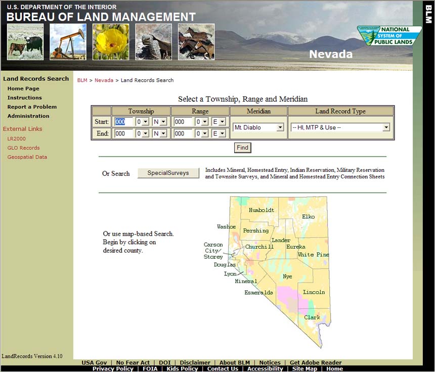
Most Public Land Records are organized by township. To find a Master Title Plat, Historical Index, Use Plat or Rectangular Survey Plat, the user must first select a township or in the case of a multiple township search, select the starting and ending townships.
To find Public Land Records in one township, enter the desired Township, Range, Meridian, and Land Record Type.
Township: Enter the Township Number, Fractional Township Number and Township Direction.
Township Number: Enter the Township Number, valid Township Numbers are 1N through 48N and 1S through 35S.
Fractional Township Number: Select the Fractional Township Number from the drop box, 0 for regular townships and 2 for ½ townships. There are no ¾ townships in Nevada.
Township Direction: Select the Township Direction, North (N) or South (S) from the drop down box.
Range: Enter the Range Number and Fractional Range Number if needed. The Range Direction for all townships in Nevada is East. No data entry is necessary.
Range Number: Enter the Range Number, valid Range Numbers are 17 ½ E through 71E.
Fractional Range Number: Select the Fractional Range Number from the drop box, 0 for regular ranges and 2 for ½ ranges. There are no ¾ ranges in Nevada.
Range Direction: No data entry is required.
Meridian: Select the desired Meridian from the drop box. Nevada has two meridians, Mt. Diablo Baseline and Meridian, and San Bernardino Baseline and Meridian. In Nevada, all but 7 townships are located in the Mt. Diablo Baseline and Meridian.
Land Record Type: Select from the drop box the desired Land Record Type. The default is set to All, but the user can select Historical Index, Master Title Plat, Use Plat, CadNSDI, Rectangular Survey Plats, Rectangular Survey Field Notes, or HI, MTP & USE.
Click Find to retrieve the desired Public Land Records.
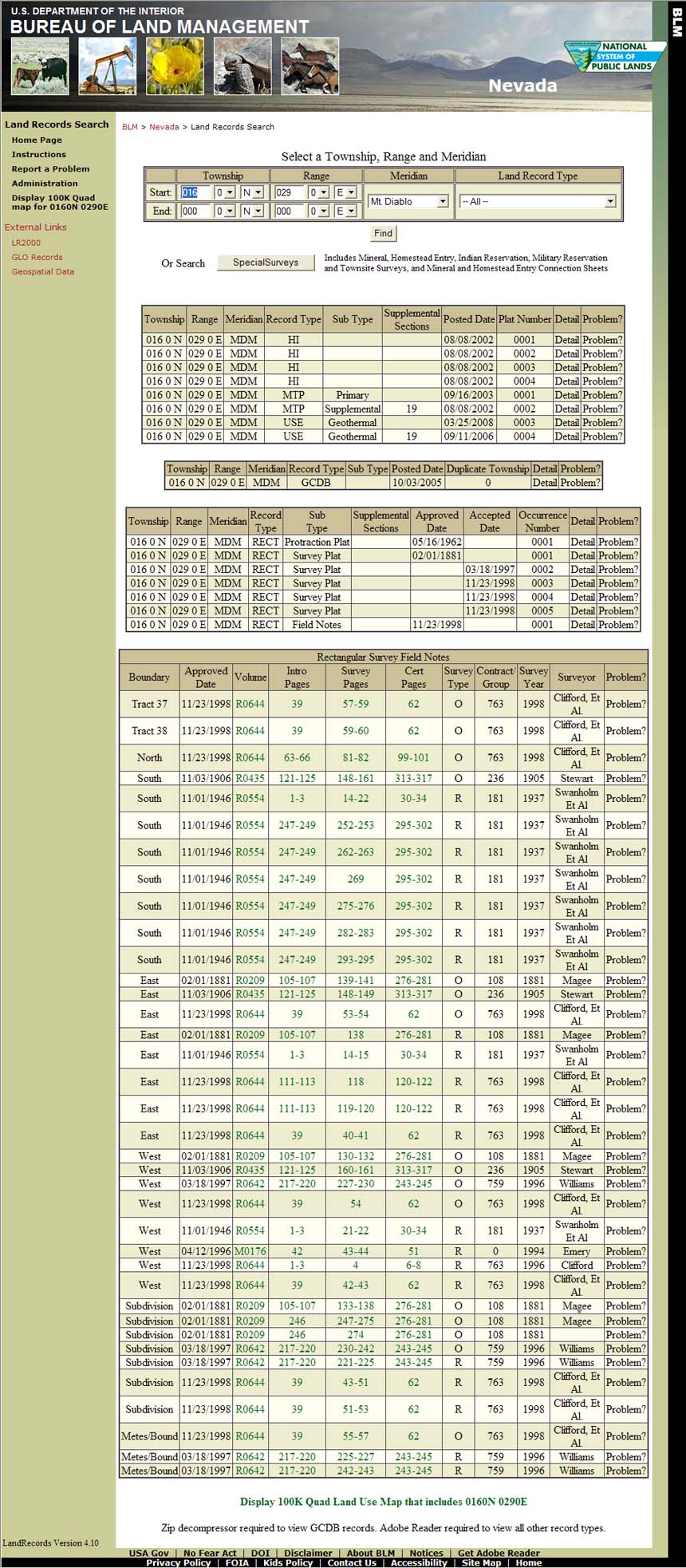
Understanding the Results of a Search
The Public Land Records for the selected township(s) are displayed in the Results area of your display which is located in the middle portion of your screen. Each record is identified by its Township, Range, Meridian, Record Type (Type), Record Sub Type (Sub Type), and Detail Report (Detail), as well as other columns specific to the type of record displayed. The last column, Problem?, allows users to report any suspected errors associated with one of the records or a problem with the system.
For example, the results for T 16 N., R 29 E., MDM, (see above) reveals that 16 Public Land Records are available. Specifically they are:
4 Historical Indices,
1 Master Title Plat,
1 Supplemental Master Title Plat (Section 19),
1 Geothermal Use Plat,
1 Supplemental Geothermal Use Plat (Section 19),
1 Cadastral National Spatial Data Infrastructure ZIP file,
1 Protraction Diagram,
5 Rectangular Survey Plats, and
1 Set of Field Notes.
Click on the desired record (any highlighted area for that record except Detail and Problem? ) to view the record. For the CadNSDI record a collection of files are stored inside the zip file and when clicked the file download dialog box is presented.
Please note: Adobe Acrobat must be installed to view a record, except for CadNSDI data.
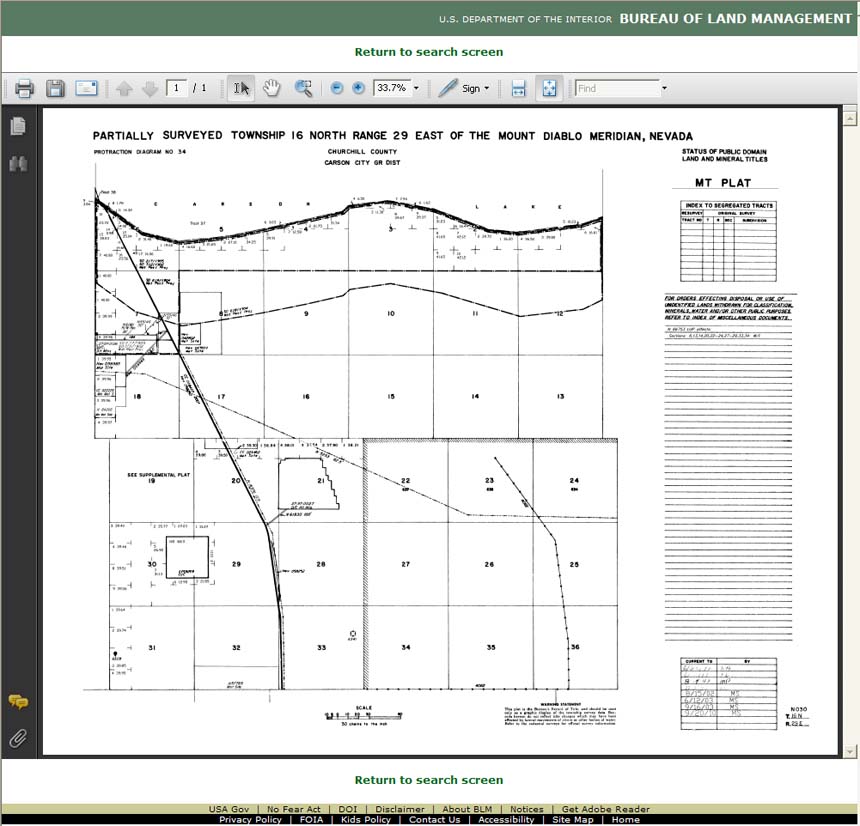
For example, to view the Master Title Plat (Primary) record, click anywhere on the 5th row (except Detail and Problem? ) and your display should be similar to the example below.
Understanding the Public Land Records Results Display
The Public Land Records Results Display lists each available record on a separate line or row. Each row is further divided into a number of columns or fields, depending on record type. The fields are defined as:
Township: The selected Township is in the format TTT F D, where TTT is the Township Number, F is the Fractional Township Number and D is the Township Direction N for North and S for South.
Range: The selected Range is in the format RRR F D, where RRR is the Range Number, F is the Fractional Range Number and D is the Range Direction. The Direction is always E (East) in Nevada.
Meridian: The selected Meridian, MDM for Mt. Diablo Baseline and Meridian, and SBM for San Bernardino Baseline and Meridian.
Type (Record Type): The selected Record Type:
| Record Type | Description | File Type |
|---|---|---|
MTP |
Master Title Plat | Adobe PDF |
HI |
Historical Index | Adobe PDF |
USE |
Use Plat | Adobe PDF |
CadNSDI |
Cadastral National Spatial Data Infrastructure |
WinZIP ZIP Archive |
RECT |
Survey Plat or Field Notes | Adobe PDF |
Sub Type (Record Sub Type): The valid Record Sub Types are described in the table below:
Record Type |
MTP |
USE |
HI | CadNSDI |
RECT |
Record Sub Type |
Primary |
Geothermal |
HI | None |
Protraction Plat |
Supplemental |
Oil & Gas |
Acquired Lands |
|
Survey Plat |
|
Right-Hand-Margin |
Potassium |
Field Notes |
|||
Townsite |
Potash |
||||
Phosphorus |
|||||
Sodium |
|||||
Coal |
|||||
Use |
Supplemental Section(s): Denotes the section number(s) shown on the supplemental plat. For the Supplemental Master Title Plat returned in our example above, the Record Type is MTP, the Record Sub Type is Supplemental and the record will show Section 19 as shown in the Supplemental Sections field. Please note for a Supplemental Use Plat, Record Type, the Record Sub Type and the Supplemental Section(s) fields will read Use, Geothermal and 19 respectively. Its implied that this is a supplemental Geothermal Plat as the field Supplemental Section(s) contains the value 19.
Posted Date: The date the record was posted to the Intranet and made available for public viewing.
Current To Date: The date the notation was made to the record.
Plat Number: For the most part, it is a sequential number used to identify the chronological order of the records. For example Historical Index 0001 was created before Historical Index 0002. Future enhancements to this site will include the From and To dates for each Historical Index to assist users in finding the desired record timely.
Detail (Report): By clicking on Detail, the user will have access to additional information about the selected record that because of space limitations could not be included in the Results area of the display.
Problem?: By clicking on Problem?, the user may submit a report detailing possible errors found on a particular record, or problems encountered with this web site.
Duplicate Township: Townships that have the same township and range name but are actually different townships. For example T0010NR0320E Nevada and T0010NR0320E California. Nevada townships will be designated 0. If a duplicate township exists it will be designated A.
Approved Date: The date a plat or set of field notes was approved.
Accepted Date: The date a plat was accepted.
Occurrence Number: A chronological sequence of numbering for multiple numbers of plats and field notes within a township.
Additional survey records that are more commonly referenced by survey number, reservation name, townsite name, mining district or national forest can be found by selecting the Special Surveys button.
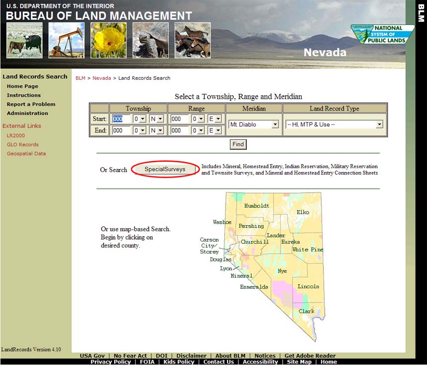
Entering the desired search criteria and record type, then selecting the Find button, will retrieve the available records associated with the information entered. Click anywhere on the record row (except Detail and Problem) and the plat or field note image associated with that records will display.
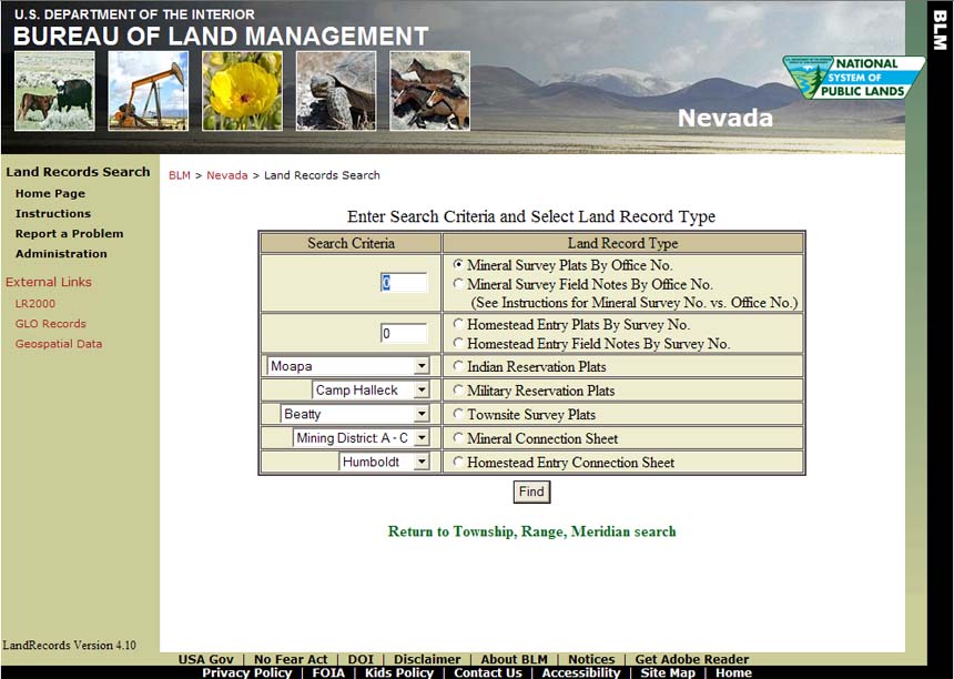
Some important information to know about Special Surveys:
Mineral Survey Office Numbers vs Mineral Survey (Lot) Numbers
Early mineral surveys in Nevada were numbered to be unique within each mining district. Because there are many mining districts, this practice created several mineral surveys within Nevada with the same name such as Mineral Survey No. 37. Around 1895, the General Land Office decided to make the numbering system unique within the state rather than individual districts and reassigned Mineral Survey Office Numbers to existing Mineral Survey (lot) Numbers. Mineral Survey Numbers and Mineral Survey Office Numbers are identical after about 1895. The mineral surveys having a number greater than 1714 have the same lot and office number. The mineral connection sheets for the mining districts show, in most cases, two numbers for the pre-1895 mineral surveys. The Mineral Survey Office Number must be used when querying the land records site. Refer to the appropriate mineral connection sheet to obtain a Mineral Survey Office Number of a particular mineral survey.
The mineral connection sheets are maps depicting mineral survey locations contained in a specific mining district. The appropriate mineral connection sheet can used to determine the office number of the mineral survey (see above). The Comstock was the first official mining district, organized in 1859, 5 years before Nevada's statehood. Numerous mining districts were formed throughout Nevada in the following years. The districts formed followed common practice and established rules to follow. The local naming convention of a particular mining district often changed and most mining districts have numerous common names. Records pertaining to the mining district are incomplete and the total number of districts is unknown. Often, a research of the various sources is needed to locate a specific district. The Nevada Bureau of Mines and Geology website has additional informative links such as MINING DISTRICTS OF NEVADA, (Tingley, 1998), a comprehensive alphabetical listing containing brief descriptions of the district, including other commonly used names. This site also has links to two maps, MAP OF MINING DISTRICTS IN NEVADA, dated 1946 and METAL MINING DISTRICTS IN NEVADA (Schilling, 1976). Two additional mining district maps are at Mining Districts and Mining Camps, 1908, by (J.B. Menardi Co., 1908) and Index to Nevada Mining Districts, a listing of the districts by counties.
Patent Numbers vs General Land Office Numbers
Before July 1, 1908, the General Land Office (GLO) assigned reference numbers in the upper left-hand corner of each patent document. No official patent numbers were being assigned at that time. After this date, patent numbers were assigned consecutively and should appear in the upper right-hand corner of the patent. Some earlier mineral survey plats have a GLO reference number referring to the patent instead of official patent number.
Using Adobe Acrobat:
When you select a record for viewing, your browser opens the file using the Adobe Acrobat Reader plugin. Using the plugin tools, represented by icons in the toolbar at the top of the image, you can manipulate the image to view or print the area of interest, or to save a copy to your computer. The icons shown are for version 8 of Adobe Acrobat Reader; their appearance may be different for other versions, but their usage and functionality is similar. The toolbar toggles on/off by pressing function key F8. Roll your mouse pointer over any of the icons in the toolbar to display their function. If you don't see an icon you need, you can add it by right-clicking on an empty part of the toolbar, and selecting More Tools... from the pop-up menu. 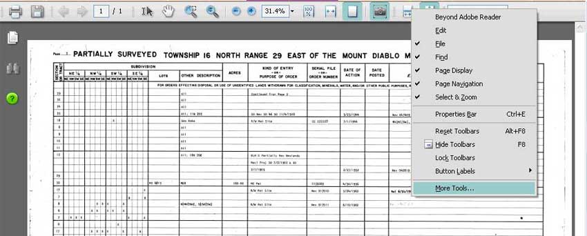
Viewing a Record
Click ![]() (Fit Page Icon) to view the entire record in the current window. The
(Fit Page Icon) to view the entire record in the current window. The ![]() (Fit Width Icon) and the
(Fit Width Icon) and the ![]() (Actual Size Icon) display the document to fit the width of your screen, and to display it at actual size, respectively.
(Actual Size Icon) display the document to fit the width of your screen, and to display it at actual size, respectively.
Click ![]() (Marquee Zoom Icon) to enlarge a selected area. Click and drag to draw a rectangle around the area you wish to enlarge.
(Marquee Zoom Icon) to enlarge a selected area. Click and drag to draw a rectangle around the area you wish to enlarge.
Click ![]() (Hand Tool Icon) and then click and drag to center the zoomed image as desired.
(Hand Tool Icon) and then click and drag to center the zoomed image as desired.
Printing a Record
Click ![]() (Printer Icon) to print the entire record. For best results, print on ledger size (11" x 17") paper. Ledger size copies allow the user to view the entire record legibly. Tip: Some Postscript printer drivers do not print Adobe Acrobat image files reliably. If your printout is blank or shows only a portion of the record, try clicking the Advanced button in the Print Dialog and checking the Print as image checkbox to print.
(Printer Icon) to print the entire record. For best results, print on ledger size (11" x 17") paper. Ledger size copies allow the user to view the entire record legibly. Tip: Some Postscript printer drivers do not print Adobe Acrobat image files reliably. If your printout is blank or shows only a portion of the record, try clicking the Advanced button in the Print Dialog and checking the Print as image checkbox to print.
Printing a Portion of a Record
Method 1: Select the portion of the record you wish to print using the Marquee Zoom Tool, then click the Printer Icon. In the Print Dialog, select Current view for the Print Range. The Preview pane in the print dialog shows a thumbnail view of what will be printed. Letter size (8 1/2" x 11") paper is ideal for printing selected areas of a record.
Method 2: Click ![]() (Snapshot Tool Icon) then click and drag around the area you wish to print. Click the printer icon. In the printer dialog, the Print Range should be Selected Graphic and the Page Handling should be Fit to Printable Area.
(Snapshot Tool Icon) then click and drag around the area you wish to print. Click the printer icon. In the printer dialog, the Print Range should be Selected Graphic and the Page Handling should be Fit to Printable Area.
Saving a Record
Click ![]() (Quick Save Icon) to save the record to your computer.
(Quick Save Icon) to save the record to your computer.